Home Multi-Country Search About Admin Login
Cenozoic
Cretaceous
Jurassic
Triassic
Permian
Carboniferous
Devonian
Silurian
Ordovician
Cambrian
Neoproterozoic
Mesoproterozoic

Search by
Select Region(s) to search
Hold Ctrl (Windows/Linux) or Command (Mac) to select multiple
Datangpo Formation
Click to display on map of the Ancient World at:
Datangpo Fm base reconstruction

Datangpo Fm


Period: 
Neoproterozoic

Age Interval: 
late Nanhuan (middle Cryogenian), Nh (47, 49, 52, 53, 54, 58-61)


Province: 
Sichuan, Guizhou, Hunan, Hubei

Type Locality and Naming

Guizhou. The Datangpo Fm was named by the Guizhou No.103 Party of Geology in 1967 and formally quoted by Ma Guogan et al. in 1980. The typical section is located in the Datangpo manganese mine in Songtao County, Guizhou Province.

[Figure: Type section of Datangpo Fm]

Synonym: (大唐坡组)


Lithology and Thickness

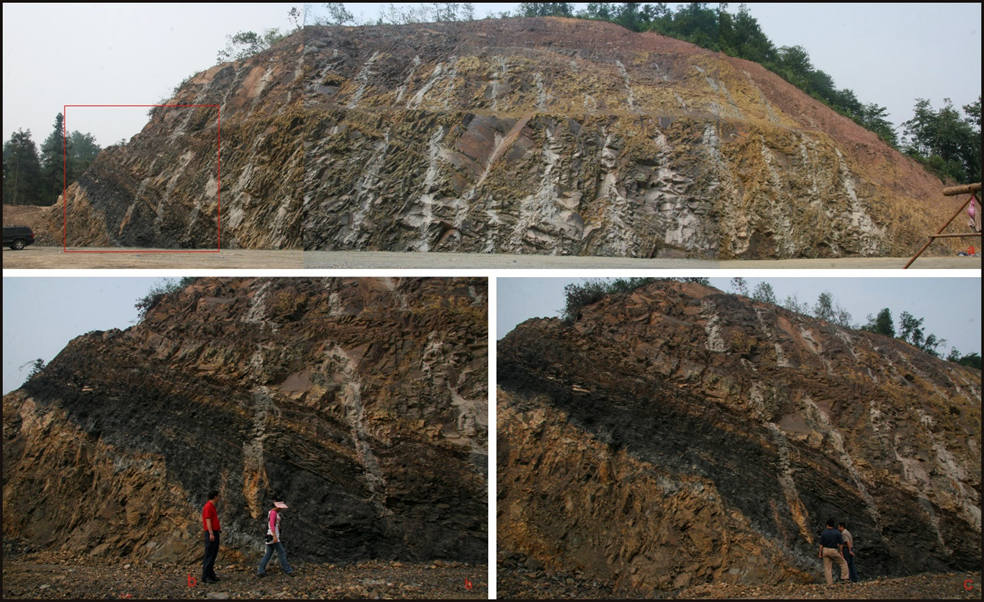
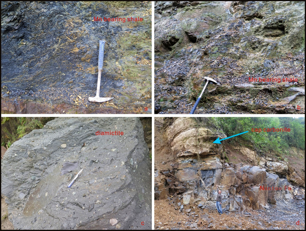
The Datangpo Fm is a suite of manganiferous rocks, which is an interglacial deposit between the underlying Gucheng tillite (Gucheng Fm) and the overlying Nantuo tillite (Nantou Fm). It is dominantly composed of black-to-black gray, thin-bedded siltstone and silty shale intercalated with manganiferous shale and limestone, with a thickness of several to about 200 m. In Songtao area of the northeast Guizhou, it is the thickest, and eastward to Hunan and Hubei, it begins to thin out. Thickness is about 200 m.

[Figure: The Datangpo Formation in Fenghuang City, Hunan Province. a-c-The section of the black shale of the Datangpo Formation overlapped by the Nantuo Formation (tillite)]


Lithology Pattern: 
Siltstone


Relationships and Distribution

Lower contact

The Datangpo Gr rests conformably on the underlying Gucheng Fm tillite

Upper contact

Conformably underlies the overlying Nantuo Fm tillite

Regional extent

The Datangpo Fm is widely distributed in Sichuan, Guizhou, Hunan and Hubei.


GeoJSON

{"type":"Feature","geometry":{"type":"MultiPolygon","coordinates":[[[[107.95,32.58],[109.43,32.24],[110.86,31.74],[111.35,31.48],[111.66,31.06],[112.36,30.17],[112.64,29.83],[113.21,29.53],[114.05,29.23],[114.77,29.33],[115.68,29.65],[116.6,29.92],[117.08,30.23],[117.58,30.38],[118.56,30.25],[119.55,30.15],[120.6,30.28],[120.45,29.97],[120.15,29.55],[119.04,28.79],[117.74,28.17],[116.93,28.14],[116.13,28.47],[114.87,28.38],[113.52,27.43],[112.79,26.93],[112.16,26.8],[111.81,26.78],[111.41,27.1],[110.95,27.4],[110.31,27.53],[109.48,27.31],[108.84,27.05],[108.4,26.8],[107.84,26.18],[107.67,25.74],[107.47,25.77],[107.26,25.99],[107.09,26.43],[107.39,26.9],[107.77,27.28],[108.42,27.8],[109.13,28.26],[109.88,28.76],[111,29.24],[111.39,29.44],[111.69,29.61],[111.43,29.81],[111.03,30.11],[110.9,30.84],[110.55,31.04],[109.95,31.07],[108.92,31.2],[108.2,31.89],[107.95,32.58]]]]}}

Fossils

It yields microplants: Trachysphaeridum rude, T. cultum. T. Simplea; algae fossils: Eosynechococcus datangpoensis, Nanococcus vulgaris, and fungi: Eoastrion sp. etc.


Age 

A Rb-Sr whole rock age of 739 Ma is acquired from Gucheng of Changyang County in Hubei Province and another age of 728±27Ma (by Rb-Sr whole rock method) is acquired from Minle of Huayuan County in Hunan Province. Interglacial of late Nanhuan (middle Cryogenian), hence between Sturtian and Marinoan glacials.

Age Span: 

    Beginning stage: 
Cryogenian

    Fraction up in beginning stage: 
0.7

    Beginning date (Ma): 
660.50

    Ending stage: 
Cryogenian

    Fraction up in the ending stage: 
0.94

    Ending date (Ma):  
640.10

Depositional setting


Depositional pattern:  


Additional Information


Compiler:  

Extracts from The Neoproterozoic Erathem (chapter in Stratigraphic Lexicon of China, draft of 2022) by Gao Linzhi, Ding Xiaozhong, Zhang Chuanheng, Zhang Heng.